Showing posts with label The Andes. Show all posts

29.3.11

Journal: Day 32

I'm going home tomorrow. "Home" of course being a highly subjective reference, since 2 days after getting 'home' I'll be going home to another 'home.'

We're in Chile - San Pedro de Atacama to be exact, in a hostel set amidst the driest desert on the planet. The land around here gives off a very alien impression, and the complete and absolute absence of life from the terrain shapes an atmosphere resemblent of another world. Not one single blade of grass penetrates the sand, and the rocks and canyons exemplify the planet shaped through pure geological forces - the real whim of the Earth.

Anyway, we rented bikes today and make a 36 km loop through the valley of the moon (el valle de la luna), down a more or less paved path that runs between terra cotta cliffs, towering stand-alone sand dunes, salt flats, and colorful odd anomalies in rock structure that make you wonder if some divine creator once ate some of that cactus that grows around here.

(Realization: biking through desert sand is an unpleasant task)

Chipping raw salt
We hit the end of the road, ventured down a dirt road so poorly maintained that bike travel was nearly impossible, until we found a abandoned salt mine, where massive (and we're talking near 100 kilos) salt crystals and blobs were visible in the side of the cliff. I knocked off a handfull with a rock to bring home.

Our days in Chile have been few, but its certainly been a change in pace and surroundings from the highland markets and cobble stone streets in which I'd set a lifetime record for 'most dead chickens seen.' Instead we found pedestrian malls, mediocre clothing boutiques, and other wonders of the western world.

Upon arriving in Arica, our first Chilean destination, we, of course, hit up the tallest place around - an ocean-side overlook on some cliffs a good 100 meters above the town. From there, we spent our valuable time sitting and waiting for hours in the early morning until the groggy clouds moved out to sea and left us with a sunny, although cool and breezy, air around us.

The rest of our day we spent sitting on the beach, witnessing 90 degrees of the suns daily path. When it got kind of cold in the breeze, I carved out an inlet in the sand band large enough for me to lay inside and take a nice warm nap. It was pleasant. While George played in the sand, I made adventure out of trying to run quickly to large rocks exposed occasionally by receding waves, then stand on them and get hopelessly wet as the next current rolls in.

We spent our next night on bus (a bus on which we found our self by fluke put in the down stairs first class seats), and arrived early this morning to San Pedro.

Its night time now. Tomorrow morning we'll cross the mountains at the Paso de Jama - one of the highest navigable roads in the world, and get in by night to Salta, Argentina - a city I've learned to navigate in my four previous visits to the gateway to the north.

The stars in the desert are unlike anything I'd ever imagined seeing. In the driest place on Earth, free of humidity, and in most cases, human settlement, the stars spout out brightly, even as the last traces of the blue sky linger after sunset, in a psychedelic fusion of day and night. Then, in the dark night, the milky twinkle of the sky reaches down to the horizon all around, and the silhouettes of colossal mountains dominate the skyline.

Tonight, on the last night of what I've come to see as a life style, I made delicious hot chocolate to share with my hostel mates on a sub-zero (C) desert night. 

21.2.11

Journal: Day 19

San Lorenzo - Ecuador

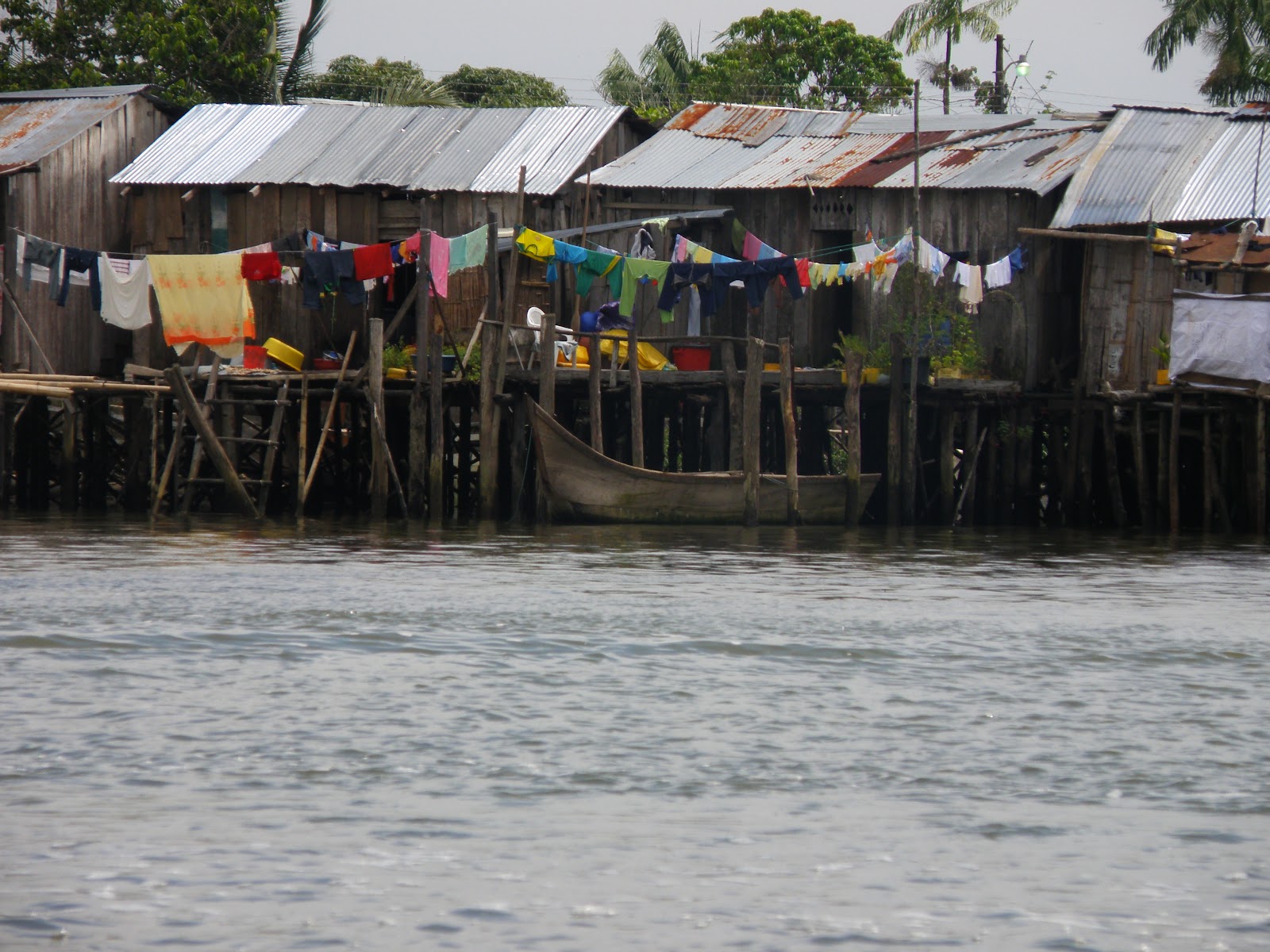
A long day of several buses from Quito has landed George and me on the northern Ecuadorian coast, near the Colombian border. It's a fairly swampy little town, half built on stilts holding tin-roofed wooden shambles high above the salty mangrove marsh below.

We've witnessed a major culture change here as our geography has drastically changed. For the past 20 days we've gone up and down through the cordillera, wandering highland markets, incan ruins, and 4000 meter mountains. Now, in one days transit we find ourselves amidst delicious sea food and fruit, warm breezes, hot (scalding) sun, mud, and people who walk barefoot in nylon shorts and muscle shirts instead of wrapped in a plethora of blankets. Its and Afro-Ecuadorian coastal town, where large populations of escaped slaves from Brasil escaped to to freedom, and thus the strikingly distinctive culture.
We're watching the sun set over the mangroves as Bob Marley is cast over the town by a nearby truck nice enough to open its door and it pumps out nice music. Exodus. Perfect temperature - perfect breeze, Bob Marley playing, undershirt and shorts I bought for under US$5, and a delicious fish in spicy coconut sauce settling down in my belly. Just another one of the many breeds of paradise we've encountered here in the South (except that technically were back in the North right now).

We've got a 2nd story room awaiting us, with metal bars where the glass should be on the window to thus not turn away they illustrious breeze that blows all day and night. From the window you can see the ocean and the port, though there is nothing of a beach here. The mangrove swamps form a several kilometer thick buffer in between open ocean and dry land, creating a hot humid labyrinth of murky waterway through a thick green forest growing (literally) right out of the water.

Now... talking back some time...   Two days ago in Quito, we climbed to the volcano's peak at nearly 5000 meters. I love the high you get reaching the tops of mountains - it's one of the greatest simple pleasures of life on Earth, but this climb could more-or-less be counted as just slightly unpleasant.

Steep volcanic slope above Quito
Even the starting altitude for the ascent - 4100 meters - is slightly head-spinning, and going up from there certainly has its price. Your ears start to hurt, you get nauseous, hopelessly out of breath, as if you wore a half ton backpack. If you walk to hard at that elevation, you start to have flashes of double vision, and things can seem to turn and spin that usually wouldn't so do. Top it all off, our up-hill trudge through mud and a fairy forest unique to the volcanic soils at high elevation in the so-called 'cloud forest' (because the landscape actually passes through the clouds, there is the constant presence of thick moisture in the air, so some very odd and fragile plants have to opportunity to grow) culminated with what had to have been a good 200 meter ascent up an old landslide of fine volcanic sand. Wet sand at a steep incline with little air about to breath makes for a trying experience.

So it was a thoroughly exhausting climb through sleet and cold wind to finally summit near 5000 meters, well into the realm of the clouds on a cold, sleety, windy, wet pile of rocks way up in the sky. Our expectations of seeing the entire world spread out below us from our perch in the heavens was crushed by the reality that cloud cover and fog made it had to even see each other if we wandered too far away.

Then, on the way down, about halfway down the volcano, the thunder broke into a light, cold, highland rain shower, effectively turning out entire route back into a path of black slimy mud, and soaking everything from my double layered pants to my llama wool sweater to my sand filled shoes, and installing a permanent trembling shiver in my spine for the long way back.

Random thought - George and I got a good kick out of the three or four others we saw headed down the mountain - well decked out with expensive hiking sticks, north face jackets, windbreakers, hiking boots and goggles, some of them even with a local guide. We went up in pajama pants over sweatpants, wool sweaters, and the same cheap sneakers we've hauled around the rest of the continent.

Our days before that in Ecuador were slightly odd at best. Coming into the country, we decided us to veer east to take the most out-of-the-way, gringo-unfriendly border crossing we could find. la Balsa, it is called. The process was long and not straight-forward. From Chiclayo, we took a short 6 hour overnight bus to a jungle town in northeast Peru, where we waited for the sun to rise before heading out to find transportation to the next in a chain of towns my lonely planet guide instructed us to pass through. We found a ride, not in a bus like in Argentina, not in a van as had become common in Bolivia and Peru, but now just in a simple sedan, jam-packed with people in the front, back, and yes, in the trunk. The driver made his route between towns in his own little car, and people payed to come along.

That marked our first passage through true jungle, so the view out the window never got old. Since we left just as the sky began to glow pink with hints of morning, we got the spectacular view of the sunrise over the highland rain forests as we made the trip. Flawlessly complacent pools of water flooding expansive fields of small square rice patties reflect the morning sun, giving the appearance of portals to a newer heaven beneath the ground. From the car, you get the idea that, jumping in, you would fall through days through clean peaceful air and the balmy warmth of the tropical sun that we felt on our skin outside.

Anyway, arrival at our never small town meant just another search for transportation farther down the line and out of Peru. We took our last little car to our border town destination - a small wooden bridge over a river with a mud street and rickety bamboo shanties on either side. Locating the immigration office on the Ecuadorian side, a small bamboo building with just three walls leaving it open to the road in front, we set out to find the actual guards who would stamp our passports and facilitate a legal entrance into the country. Sitting at a table in the mud, military uniforms unbuttoned to expose their round sweaty bellies, we found them gambling for US quarters a little ways down the streets. They told us they would come and help us cross as soon as their game was done, in about an hour.

Then, the facts get blurred in my mind, because what followed was essentially a near hourly alteration of our itinerary as we spent several nights on buses and decidedly bypassed the majority of the Ecuadorian highlands in the interest of arriving to Quito with days to spare. The final stint, however, did include being dropped off by a bus drive at god-knows-which street corner in Riobamba at around 2 in the morning, then being left on our own in the cold amidst the wandering drunken transients of the night to find the train station that was pivotal for our plans in the coming day.

We took a taxi to the train, but the driver told us he would rather leave us outside the volunteer police station, because it would be a safer place to wait. Not that the station was open or even occupied by anyone at the time...

So our plan was to wait on the benches until the station opened at 6 like my travel guide said, but after some hour or so of disturbingly shady foot traffic that tended to turn its attention in the way of the two gringos in an abandoned city center at night, we grew a bit nervous and took to walking around, at least to where the station security guard could see us. Upon our first conversation with the guard, we found that the train and station had been closed for months, and were not to open for a few more. Well, our plans were shot, and so several days off scuttle through the highlands ended with one last 3 am bus to Quito, where we arrived just in time for sunrise. 

Fine Cuban cigars and some vile Ecuadorian wine celebrate our arrival to Quito, what had been a major checkpoint in our minds, marking the end of our long travels north.
By now we've traveled to the equator (0°0') from Cordoba, Argentina (31°24'). That's about equivalent in distance with a trip by land from Central Texas, through all of Mexico, all of Central America, through Colombia and to Quito, Ecuador, all in about two weeks, and is even farther than a straight shot from Austin, Texas to Juneau, Alaska.


It certainly feels good to say that, you know.

15.2.11

Journal: Day 13

"Pyramids"
Lima turned out to just be so awfully ugly that we shortened out stay in the city to a reasonably modest hour-long meal in a chinese restaurant in one of the various bus terminals before modifying our itinerary significantly and heading north to a town called Chiclayo, Peru. We got in around 05:00, and, as we've grown accustomed to doing, waited for the sun to rise before venturing out, then took a stinky little jam-packed van about 45 minutes north to see the famous "pyramids." As it turns out, though they may have been pyramids 500 years ago, what remains may not necessarily warrant the title, and we found ourselves looking ponderously and massive heaps of very geometric crumbling mud. Yet, not even they failed to attract a crowd of senior British tourists.

So we took another van to the next significant archeological site down the road, but fairly quickly gave ourselves up as lost, flagged down another van to Lambayaque, where we headed for the museum of the Senor de Sipan. The museum, it turns out, was surprisingly legitimate, but it did some nasty work with the San Pedro I had eaten hours before. Thus, I entered a bleak and empty, yet largely expansive world, and the very dark museum with spot-lighted golden relics spread throughout transformed into a vacuum space through which I was floating from one myseteriously lit golden sculpture to another. Not to mention, a whole posse of tiny golden and ceramic, jewel-adorned figured, built as guardians of the dead, all had a story of their experiences as a tomb guard to mumble to me. Relearning the physical bounds of this new limitless world just became too shocking, so I ended up vomiting outside.

Our pier
Coming back to Chiclayo, we caught a bus to the ocean (a surprisingly hard vehicle to track down...  we literally met several people who could not tell us where the ocean was), and walked out onto an old train pier, marking our first steps together over the Pacific ocean (even though we'd seen if fromt he bus window the entire day before.

Climbing over the railing, I sat on a timber that jut out, an expected result of such imperfect construction, over the ocean as the sun set, and a truly indescribable peace came over me. I can't recall ever having felt that way before, and I don't ever want to forget how it was, because I can't imagine that all people alive get lucky enough to feel as I did some time or another in their lives. Maybe it was the act of getting to the sea, or realizing that we'd crossed an entire continent, coast-to-coast. Maybe it was just sensing the reality of watching the solemn sun set over the Pacific at a Peruvian that was real in a very modest way. Or maybe, it was just taking the time to realize what it is that I've been doing these past days, and how far I'd come to arrive to the rickety pier on which I was perched above the sea.


Either way, the feeling I got hinted that everything in the world was just the way it's supposed to be, and that I'd found the perfect point on the global scale to sit my tiny body down and bring balance to it all. I could have died on that spot and had nothing to be ashamed of or sorry for. That's how I'd like to be remembered, in a living, breathing photograph of me in that spot, feeling the world around me.


If they were to make a movie of my life, the very last scene before it fades to black would be that 18-year-old unshaven dirty kid with a bandana in his long hair, hanging off the edge of a broken pier, set before the fading sun over the sea.

I know, I'll chase the feeling 10 months and and a thousand miles if I have to, but when I get to the edge of the world and that indescribable feeling transcends the body, its more than worth it. I hope I never forget that sensation or those two long hours on the pier for the rest of my life. This is freedom. Bring it on, world.

14.2.11

Journal: Day 11

So I've missed a few days of writing, particularly due to a few busy days in Cusco dealing with Machu Picchu and the Sacred Valley. We also saw Lake Titicaca. I'll touch on that later.

Yesterday, we left Cusco at 16:00 on a bus said to arrive in Lima at 11:00 the next day. We just happened to share that bus with the world's most unpleasant baby, who cried and screamed for hours and hours straight without any caretaker addressing the problem in any way. Hours so continuous wailing is a clear sign that a baby needs something.

On top of the baby, as we made the full pass over the Andes mountains in the middle of the night, the windows began to ice over on the inside of the bus. That means that it was clearly too cold. I found myself in the fetal position, head and arms pulled inside two wool jackets (and a third covering my legs), a bandana over my mouth to keep the dry mountain air from ravishing my throat, wearing two hats, and two pairs of pants. For as little as it did yo keep the cold out, it wasn't even a possible position to maintain, because as our driver zoomed through sharp switchback curves, a body not well-braced would be thrown off the seat. It was a long, long night, and I ended up doing most of my sleeping as we passed by morning along Peru's southern Pacific coast, some of the least attractive landscape I've ever encountered.

Now, allow me to backtrack substantially, and recall some of what we've experienced in the undocumented days before today. We spent an entire day in La Paz out and about to see such the spectacular city. As it turns out, in passing conversation with a taxi driver we had hailed from the bus terminal upon arrival, he offered to take us the next day on a tour of the major sites of the city for 40 Bolivianos - just a big more than 5 US dollars. We made the deal and sure enough, there he was the very next day, waiting at 9 am out the front door of out hostel. He was a short man of feeble stature (and who's name escapes me), fluent in Spanish, Quecheua, and Aymara, two major indigenous tongues of the Americas.


So with our driver we passed through a richest neighborhoods that fill the lowest basin of the bowl shape of La Paz, then went up to all the highest points of the crest around to find all the most spectacular views of the massively expansive, surprisingly modern city scape built on such an impossible mountain grade, seemingly a still photograph and an entire metropolis just poured, cascading down the sides of the mountain and collecting in a fine shamble of tall and colored glass buildings, set in front of complimentary rugged, rough, dangerous, and unconquerable mountain-scapes towering behind. 

La Paz

He even took us on a quick 20 minute jolt from the city center to the Valley of the Moon national park, a preserved landscape of eroded mud fenced of in the plain center of a residential area.

Dried baby llama
So our 3 hour voyage ended back at the hostel, where we spend time exploring the witches' market that lay outside out door. Common fare includes, but is not limited to, dried llama, frog, and bird carcasses, carved amulets meant to remedy any ailment, a smorgasbord of dried herbs, ripe to be smoked, brewed, or rubbed on the skin, and various forms of preparation of certain psychedelic cacti. 

The next morning we found ourselves on an early bus out of La Paz to Copacabana, the Bolivian border town on Lake Titicaca. We ferried to cross a skinny outcropping of the lake, and traveled on a bus atop a rickety metal flat boat, floating amongst wooden fishing ships and sailboats. Upon arrival in Copacabana, we bought bus tickets several hours in advance for a trip to the Peruvian border, and headed up several hundred meters to a stone monument and lookout over the lake. For an hour we climbed an impossibly steep slope with no real marked trail, wondering how many people could commonly visit this place, only to find, upon reaching the top, a massive stone staircase pouring down the other sided.


The view of the lake, needless to say, was spectacular. With such dry, clean, clear air at such a high altitude, the water reflects brilliantly the color of the sky, creating the illusion of no distinction between the two. Except, of course, for the mountains on the horizon. Although, the horizon seemed for some reason to fade away around its intersection with the water, leaving only visible floating mountain peaks, fading up out of the horizon and into the sky. Quite spectacular, indeed.


Lake Titicaca and on to the horizon.
 
Cusco's tourist center. 'Rainbow' is the official color.


Then from Bolivia onto Cusco, Peru, and the Sacred Valley of the Incas. Cusco is an odd city, being both the Americas' oldest continuously inhabited city and a major destination of international tourism, there is a visible dichotomy. In the tourist center, the same dish available for 17 USD is sold literally two blocks away in a place where travelers don't often wander, the same thing is sold for a dollar. Cusco has Disney tours as well. You can book a trip with Disney and go to Cusco and Machu Picchu. I found that striking.

Then we also went through the sacred valley and up to Machu Picchu.

10.2.11

Journal: Day 5

Daily elevation loss: 4300 meters. Not many places in the world allow one to take a bus that passes through 4700 meters elevation, and in two hours bottoms out at 400. But that's why Bolivia rocks. After getting into La Paz, which is quite possible the most...

Shit its raining.

Yes, we have fallen victim to a tropical shower here in the principle steps of Bolivia's Amazon Basin. Anyway, La Paz rocks; I'll get back to that later.

High Andean plains outside La Paz.
We took an early bus this morning down the mountains, finally making our way off the puna. Coming over the Andes outside La Paz, we peaked at 4600 meters in a wide rolling yellow highland tundra widely inhabited by llamas. Llamas also rock, and it hurts me inside to know that I may never see so many all together in one place again. Towering above this llama haven, we finally caught a good steady glimpse of those stereotypical Andean peaks we'd been looking for from Ushuaia to Bariloche to Mendoza to San Juan to JuJuy to Tupiza to Potosi - unbelievably massive, sharp, jagged rock peaks that actually rise up above the clouds that swirl around them, totally devoid of even the smallest hint of life. That's the kind of think one sees in documentaries and in magazines, but never imagines he will get to stand in front of and feel. I am humbled to see a creation so awesome.

Just like that, we hit a very definite point where the bus began to head down...    down, down, down nearly 4300 meters directly to Bolivia's slide of the Amazon Basin - an amazing change of terrain to witness in just 2 hours. Where else on the planet can you descent from snowy tundra crawling with llama set before such massive rocky peaks to a cloudy tropical forest 4 kilometers directly below? Probably nowhere.

Our chosen path of descent carries with it the title of "the most dangerous road int he world," a name inspired by the high fatality rate of travel on its paths, no doubt due to the lack of guard rails as the gravel road plummets down the sides of mountains. Descending, just as the yellow grass and mosses began to grow longer and greener, we entered the clouds - a major milestone in a a road trip down from the heavens. Riding along mountain ridges and looking over the edge, the forested earth just faded out to white in the near distance, giving rise to the question of whether or not the ground actually exists below us. We continue, and as the mountains above use disappear into the sky, we hit the breaking point of the clouds.

And just like that, we've left the realm of the sun and stars and clouds and moon and in front of us lies the massive expanse of the tropical rain forest, rolling on an infinite sprawl of hills channeling countless streams and rivers between them. The forest sprawls on as far as can be imagined, and the road improved to cobblestone as we re-enter a realm in free from strictly prohibitive slopes, and thus one again rich in human settlements. 

Now, I find myself perched atop a mud brick wall in the forest outside Coroica writing these words to be read. We spent our day off the bus eating a delicious meal of spicy river fish with fried bananas, then took a walk to feast on the abundance of tiny wild tangerines that grow on the broad-leaf trees. My discoveries of the day are two-fold: First, the rain forest floor does no lie where it appears to, but rather a good meter or so under crushed subdue vegetation that will swallow you up if you don't step just right, and second, it rains a lot in the jungle.

Journal: Day 4

Making our was back to Sucre was quite an adventure, and as we came to realize that, contrary to what the locals had told us, there would be no trucks returning to where we'd come from that day. We ended up hitch hiking with some workers for a health organization, and with them made the high twist trip back. Its a good thing we found them, too, because there were neither many leaving vehicles or many sleeping accomidations available in that little town. 

Even better is that I spent all last night with a horrible fever having hallucinations and puking out our 2nd story window.

Journal: Day 3

Two hours in the back of a freight truck has landed George and me in a small and apparently nameless indigenous village at around 3600 meters above sea level. Our decision to come here was made purely by considering the quality of all vehicles departing the truck stop (a seemingly random open dirt plaza where any truck could come by and stop to pick up passengers), then carefully choosing the worst, and getting in. We were loaded into the wooden bed behind with another 30 or so passengers, all local campesinos making their way back out of town, carrying fares of birds, potatoes, and babies. There was little room to stand, and certainly no room to sit down, I resorted to the gut-wrenching ride one can experience perched atop the wooden walls of the truck bed looking down over the cliff our clumsy truck traversed so well. 
After ascending into the mountains surrounding Sucre and penetrating much farther into nowhere than I ever believed to exist in the US, my knuckles began to fade into white as I gripped the metal framing of the truck that I clung onto to keep from falling off the wall, and down the 300 meter drop that lay just centimeters from our wheels.

Traditional architecture has not changed so much.
But, we hopped off two hours later at the first seemingly pleasant and hospitable town, where we ate a meal of some soup and spicy chicken for 10 bolivianos. Notable qualities of our restaurant included their manner of meat storage - on a table by the wall. Really the only difference between this village and any ancient ruins one may find around these parts is that ancient ruins were built long ago. Other than that, the architecture and manners of construction has not changed at all. From adobe mud walls, to stone terraces, to straw roofs, it feels like falling back in time. 

Writing this entry with the little town in view below.
We were taunted in Quecheua (or so we came to conclude) by a large group of native Bolivians as we wandered the town, up to a large rock hill about a kilometer outside of the center of the village center, where the entire yellow glowing basin becomes visible under the closer-than-ever shining sun. I told George, I think we've done pretty well for 17 and 18 years old.


Journal: Day 2

Street food in Potosi
We're eating in the terminal in Potosi, waiting for our 17:00 bus to Sucre and the day is ending just a bit roughly. The combination of 4100 meters of altitude, 2 night night each allowing 3 hours of sleep on a bus, and spending various hours below ground breathing in dust and smoke in the mines while drinking 97% alcohol with the minors really packs a punch. I guess that's understandable. I personally, though I don't enjoy the feeling of having your head torn apart from the inside out, do appreciate it. As a firm believer that man has reached a point, believe himself now to be everything-proof, I feel that it does some good to every now and then throw one's self at the mercy of the planet and recognize how helpless we really are. 

Our guide, Jesus, and a friend from the mines.
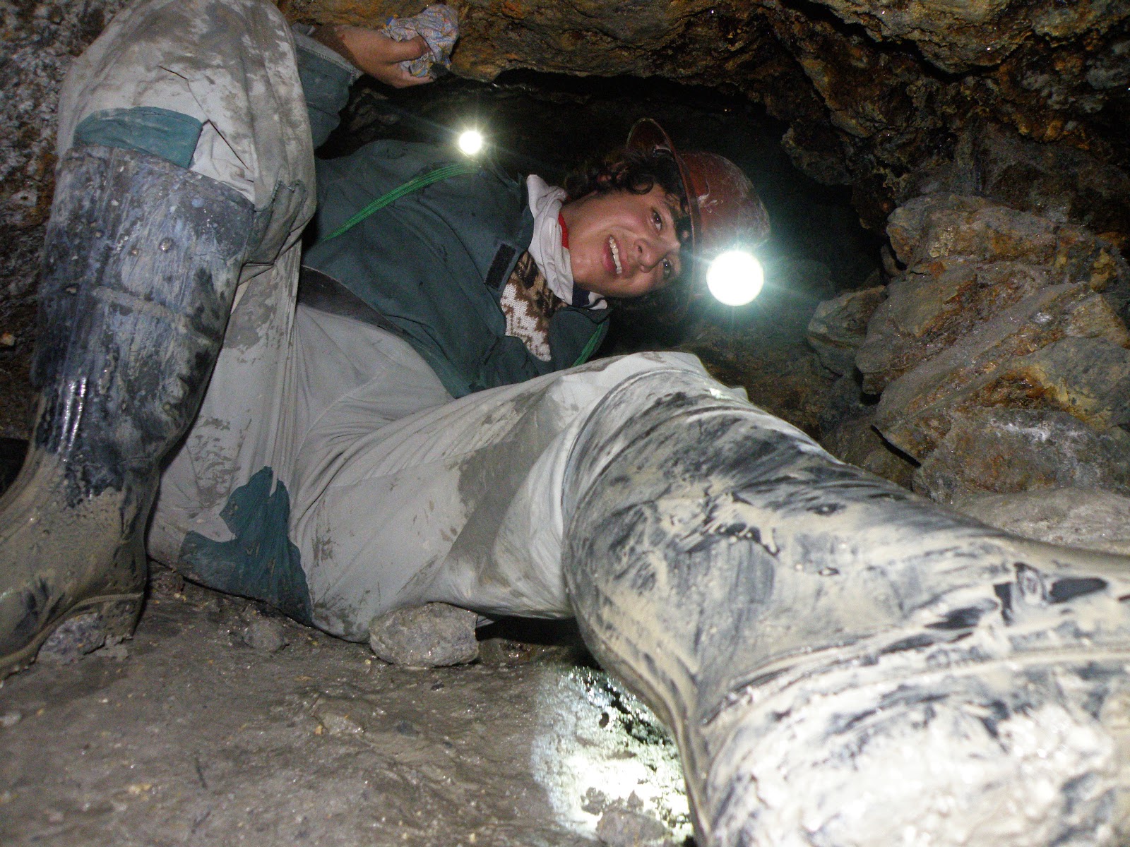
In our lengthy crawl through the mines today, we saw some pretty spectacular things. First of all, they were mines not meant by any means for touristic purposes; the were fully functional, fully staffed, and come packed with dangerous activities like running from a recently lit stick of dynamite then cupping your ears and opening your mouth so the rush of pressure through the mines would not pop your head.. George and I experienced that one first hand. We crawled through tunnels to hang out and drink with our guide's minor friends, who I suppose were supposed to be working. 

Camera flash gives the illusion of a lit-up mine. It was not so.

We dished out the coca leaves we had brought as gifts in exchange for them welcoming us into their work place, and they instructed us on how to serve the 97% cane sugar alcohol that is common fare for the minors. Mix half and half with juice in a tiny glass, then throw out three splashes - one for the Pachamama, one for the Tio, and one for the minors around you, then drink it down. And the ritual continued time and time again, all in nothing but the light that our headlamps offered.

Navigating mine shafts above Potosi
Sitting and drinking with burly Bolivian minors, some 55 years old wearing 30 years of work in the mine - one as young as 15 and just starting to work - is quite the experience, though George and I did have to fake quite a few laughs at the minors' jokes, and eventually began to throw shots over our shoulders and pretending to wince at the burn. At one point our minor gang got the idea to go show us the place that we work, a destination reached only through several tall muddy ladders and crawls through skinny, near vertical shafts, all whilst our guide announced in broken english that he was 'teepsy.' That was comforting.

Journal: Day 1

Leaving Argentina
-06:00 brings us into La Quiaca where the elevation really starts to get to your head. Breath slowly, breath deeply, and hold the air inside your lungs. Day 1 has officially begun, and waiting here in the Bolivian border town bus terminal/refugee camp feels to me like our big step into the world we've been looking for. 

Last night as I got on our big rickety bus and sat down, I just arbitrarily got this swelling feeling of extreme contentment to be doing what I was doing - just to be where I was. Sitting next to George on a bus to the gateway of our adventure just conjured feelings that top easily those of anything one could ever smoke or drink in search of the sensation. Life is good. George feels sicks. 

- Upon getting up on our first Bolivian bus, a supposed 12 hour ride which cost US$3.12, I was a bit disappointed to find that it wasn't actually as horrible as Bolivian buses seemed to be in the stories I'd heard. It had seats, windows (albeit covered in tape), and most other expected qualities of your standard low-quality bus. Then, it left the terminal of Villazon, traveled a bit more than a block, and broke. Hooray Bolivia and its buses. I guess I'm happy with that. We've now been waiting an hour by the side of the road for a new bus to come. Bolivia rocks.

-On the evening of day one, George and I find ourselves at 3000 meters looking over Tupiza, Bolivia, chewing ojas de coca y bicarbonato to maintain healthy breathing patterns. The altitude is cruel. If hiking 2 km to 3000 meters hits me this hard, its hard to think of taking on 4700 meters above Quito, Ecuador. But thats in 2 weeks. We have time to develope ourselves into full-fledged Incan highlanders. We never actually planned to be here in Tupiza, but after our bus broke down we really had no other choice, so a 21:30 departure tonight will bring us into Potosi at 05:00 tomorrow. It's kind of nice to be here, though; its quite a ways off the beaten path, and obvious reasons to be here don't quickly present themselves. In fact, when we asked a local man what kind of things are cool to do here, he showed us a map and said, "Well a lot of people like to go walk over here, and also a lot go to walk over here, but also its popular to go walk over by the river."

Tupiza - and excellent place for walking.

The view from above Tupiza
Our bus seriously didn't take a single paved road to get here, and that rocks. The entire path here was punctuated by large, half dug holes in the road, almost as if the Bolivian government has some sort of initiative to at all times sport the world's greatest quantity of unfinished road work.


This town its self sits in a small valley (about 2 km wide) in between some jagged red rock mountains brushed with yellow and orange. The people and the buildings and the landscape and the mountains all converge here to make exactly what I'd hoped to find in Bolivia: a 3-course meal with desert for US$1.40

8.2.11

La Quebrada de Humahuaca


Cafayate vinyards from the mountains
After Talampaya we spent the night on the bus as we made our way north to the province of Salta, Turing which trip the bus stopped twice to let 55 exchange students get off and take pictures of llamas. We stayed at a little provincial border town called Calafate, which boasts a vineyard that can manage to sell a liter of wine for 6 pesos (about US$1.50), and a farm that makes goat cheese. My friends and I spent our free day walking aimlessly into the mountains, trying to get as high as we could, then sitting for a good 2 hours before heading back down.

We moved on after one night to the city of Salta, which happens to be the capital of the province of Salta. Salta, which I have now visited 3 times, is without a doubt my favorite city in Argentina. It seems to be more of what people would expect from a South American city – White plastered buildings with terra cotta shingled roofs touring down the side of hills covered in sub-tropical rainforest. It’s pretty impressive. We spent a day of city tours and shopping, but got up and out by 6:30 the next morning to make the 500 km round trip through the Quebrada de Humahuaca and back. A quebrada is sort of like a valley. I have to admit, I don’t really understand the difference, but the Quebrada de Humahuaca is a long flat pass with mountains on either side that over about 600 kilometers slowly and steadily ascends into la Puna, the Andean Plateau at about 4300 meters where most of Bolivia sits. 


Adobe houses in Purmamarca

The Quebrada de Humahuaca is known for its colors, thus boasts features known as the ‘seven color mountain’ and the ‘painters pallet,’ where the muddy adobe mountains seam smeared with earthy White, red, blue, and almost green. All that is set as the backdrop for adobe Andean villages and colorful hilltop cemeteries (that demonstrate a pretty lively and potent mix between imported European Catholicism and traditional belief in the Pachamama, or mother Earth). In fact, throughout most of the Northern provinces, every hour or so you’ll pass a stone monument to the Pachamama, where travelers spit mouthfulls of a home made corn bear into a big stone basin and leave coca leaves as an offering for protection on their journey. It’s obvious that these beliefs are still very legitimate in this part of the World. 


The 'Painters Pallet' and cemetery to the right